Sobre nosotros
Servicios al cliente
Atención al cliente
Acceso Regional
Legales y políticas
Obtén la aplicación

Apunta tu cámara para descargar la aplicación
Copyright © 2024 Desertcart Holdings Limited


🌍 Adventure Awaits: Your Ultimate Outdoor Companion!
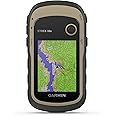
The Garmin Trex 22x is a robust GPS handheld device designed for outdoor enthusiasts, featuring a 2.2-inch sunlight-readable display, dual satellite support, and a rugged, water-resistant build. With 8 GB of internal memory and a micro SD card slot, it allows for extensive map downloads and paperless geocaching, making it the perfect tool for hiking and cycling adventures.
| Manufacturer | Garmin |
| Item model number | 010-02257-01 |
| Product Dimensions | 5.4 x 10.3 x 3.3 cm; 142 g |
| ASIN | B07RXT2JZB |
| Guaranteed software updates until | unknown |
A**R
Cheaper alternative to a gps smartwatch
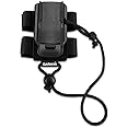
I didn’t want the cost and complexity of a smartwatch but this works a treat as a reliable gps unit when conditions make a smartphone unreliable (cold, rain, wind). It’s button/joystick controlled (easy to operate in gloves or mitts), no touch screen to go wrong, no Garmin account needed, which are all a strength, and lasts a good 30 hours in gps using lithium AA batteries. Gps (2 satellites) is really good for a unit this price (Garmin do bigger, better, more expensive ones) and locks on most of the time, the only time it has failed was when I started messing with the settings mid-walk, the unit chucked me out of gps and as I was in woods it couldn't find a signal again when I restarted the unit. Luckily I knew where I was heading and gps kicked back in when I was out of the trees. But if you just want to follow a preloaded gpx track (via cable from your computer, no wireless) zoom in and out and record the route this works perfectly, and importantly isn’t affected by bad weather or freezing hands. I tend to plan a route on other software not directly in the unit itself, and load it in. If it is on and has a gps signal this thing is always recording, so remember to clear both track and trip just before recording a new walk and remember to save the track when you finish (it automatically gives it a date and time stamp). Altimeter works well but like similar devices it needs recalibrating each day usually at the start of the walk. Compass works well and needs far less calibration. Unit comes preloaded with Garmin active maps but these can be sparse and if you walk a lot in the UK hills you’ll definitely want to get OS Topo Pro maps which comes on a micro-SD which you can put in the SD slot in the back of the unit (another advantage over a watch where I don’t think you can load OS maps). The OS maps are expensive (more expensive than the unit itself!) but can come bundled with the unit for slightly reduced price, or search out cheaper prices to the RRP. I have 1:25k OS maps but to be honest I tend to stick at 1:50k because the screen is quite small (but still bigger than a large smartwatch) and also the maps are rasterised (not vector) which means zooming too far into 1:25k makes it pixelated but sometimes that level of detail is useful. An alternative to OS maps are the Talkytoaster ones which look very detailed, specifically for UK walking, and are a fraction of the price of OS maps. The gps unit has a joystick which is easy to use but I don’t think you can lock it, so if you are not careful you inadvertently set waypoints by knocking it, so I have a cheap 3d printed clip for the back of the unit so I can clip the whole thing onto my rucksack chest harness to keep it out the way. I use a cheap lanyard too (that I had already) as this thing is shaped and weighted like an old Nokia phone and despite having some grip looks a good candidate for dropping and disappearing down between rocks! Garmin do a backpack tether for the unit but it’s expensive and the set-up above works well. All in all I’m very pleased with this unit, and it complements OS maps on my iPhone (which is better to navigate with in good conditions but a liability higher up) and physical OS maps/compass which I always carry in my pack as backup. By the way, this unit and its harness clip squeeze perfectly into an Alpkit padded cell 1 to protect and store.
C**R
Small, Fast and Accurate. V Long battery Life, Sharp Screen Image
Excellent little pocketable GPS for hiking and general outdoors use. Very familiar interface if you have used any Garmin outdoor GPS before.. otherwise there is a learning curve to customise the settings to your needs. 'Back' button is the old Page button, and works as expected..Battery LIfe is very good, and satellite acquisition is incredibly fast, even on just GPS without GLONASS running.Fitted with @TFolix screen for protection from clumsiness, this is a very rugged device for easy use.The 32X has the Compass which is very useful for static bearings, as a GPS based compass tned to give a wider variation. Altimeter is as accurates as ever - which means not very for height readings..(!) This is usual and to be expected, none of them are too good on this.. but the compass accuracy and use makes up for that.. and the barometer is useful in doubtful weather.The 22X is cheaper but without the sensors loses half its 'brain'.. so worth paying a little more for long term use.Topo-Active basic maps included are just about usable, but better to add a 2gb Micro SD card and get the Talky Toaster topographic terrain maps with truly high resolution for the best results. These maps work on most Garmin GPS units, and cost very very little. The British Isles map takes about 1.2GB on the card, so fits easily....Highly recommended as a go-anywhere GPS that you can keep in your pocket knowing it will not lose the signal.About the size of a large egg, with a curved back, it takes up very little pocket space and seems not to weigh anything at all!Fantastic little unit..Pricing was good, and from Amazon as a Garmin UK distributor.
A**R
pleased with the device but I still need my phone
I am based in the UK and so far I have been doing day hikes, so that's the perspective I'm going to rate this product on. I also have the OS explorer map for the area and installed the mobile app version on my phone.Pros:- rugged case, water resistance. Your really shouldn't be worried about accidentally dropping this device, or it submerging in a puddle, if you wipe it off quickly, it shouldn't be a problem- battery life. You can just buy AA batteries in any supermarket, have a few spares on you, and this thing can run all the time on for over a day without any problems. This means that your track is continuously recorded, you get accurate odometer readings or can view an accurate elevation plot of your hike at the end.- joystick/button controls, no touch screen. Yes, to me this is a pro. This device can be easily operated in one hand while the other hand is hanging onto branches, still working perfectly with thick gloves on.Cons:- The tiny display doesn't allow for any sort of planning or overview. Either you see a 500 yard radius around you with foothpaths and details, and then you have no idea how to get from A to B on a bigger scale or you zoom out, then you lose all details, and you don't see footpaths any more, so you don't know if a route is walkable or not. You don't want to walk on a dual carriage way, but that's all you see once zoomed out.The cons can be overcome by some home planning, so you know exactly your turns to the end, or once a day when needed taking out the phone from the backpack, do some planning on the much clearer OS map on a large screen, and once you have the route in mind you can tuck away your bulky phone and carry on with this.Conclusion: it;s great for a device that is on all the time, and you pull out on every turn making sure you taking the right path, but, for planning the trip it doesn't work. Do it before hand - or what works for me- use it in conjunction with a phone that now I need only once or twice during a hike.
Trustpilot
Hace 1 mes
Hace 1 mes